Measurement of canopy cover at edge of pavement (CCEP)
Street tree canopy is especially problematic to assess because of differences
that exist in street widths and configurations. After reviewing existing methods
and experimenting with various methods, we recommend canopy
cover at the edge of pavement (CCEP) as a standard for assessing street
tree canopy. CCEP can be measured on almost all types of roads either from aerial
imagery or by ground survey. Furthermore, CCEP
values are related to the amount of shading that streets receive, and the "canopied"
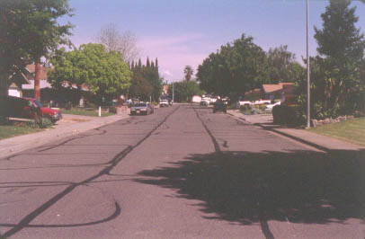
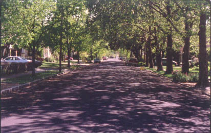
effect that is obtained when trees arch over streets. In the two photos below,
the street on the left has a low CCEP value whereas the street at the right
has a high CCEP value. Both streets are in Vacaville, CA.
Measuring CCEP from aerial images
Variations of the line
intercept method are used to measure CCEP from aerial images. Using the
hybrid line/point method, the evaluator lines up a single row of dots or a finely
divided ruler along the visible edge of the pavement. The evaluator counts the
number of dots or ruler divisions that fall on tree crowns and the total number
of dots in the sampled segment. Percent CCEP is then calculated as:
% canopy cover = 100 x (points falling on tree canopy/total
number of points along sampled lines)
While this method is easiest to apply on relatively straight sections of road,
it is possible to apply the method on moderately curved roads by using a flexible
plastic rule held on edge.
On very curved roads and those with very low or high canopy cover, it may be
more efficient to use the standard line intercept method. In this method, the
lengths of all tree canopies that intersect the line of the edge of pavement
are measured with a ruler, planimeter, or digitizer. Percent CCEP would be calculated
as for the line intercept method, i.e.,
% canopy cover = 100 x (length covered by tree canopy / total
length of sample)
Measuring CCEP via ground survey
CCEP can also be readily evaluated by using a foot survey. To estimate CCEP
in a foot survey, the evaluator walks along the edge of the pavement. At evenly
spaced points, e.g., every 3 steps, the evaluator notes whether canopy is present
directly over the point at the edge of the pavement. Hand tally counters can
be used to keep track of the total number of sample points and the number of
sample points with tree canopy overhead. A length of 1/2 inch diameter PVC pipe,
lightweight measuring pole, densitometer (a small instrument with a level that
allows one to sight a point directly overhead), or similar tool can be used
to help project a line vertically from the edge of pavement upward to increase
the accuracy of the evaluation. The percent CCEP is calculated using the following
formula:
% CCEP = 100 x (points with canopy cover/total number of points)
One advantage of measuring CCEP as part of a ground survey is that it allows
one to examine correlations between CCEP and other tree or site characteristics.
The evaluator can collect data on site or tree characteristics at the same time
that canopy is being assessed. The level of CCEP can be affected by tree species
selection, tree age, planting position, and pruning practices, and it may be
of use to know which factors are the most important in your community.