Photo points
Uses:
Monitoring the growth, condition, and survival of individual trees or groups
of trees over extended time intervals.
Materials needed:
- Suitable record book or data file for keeping photo point information
over many years.
For ground-level plots:
- A digital camera with a short focal length lens (about 35 to 70 mm) is preferred. Images from very
wide-angle lenses (shorter focal lengths) may have too much distortion, and
telephoto lenses (longer focal lengths) may not have a wide enough field of
view to be practical.
- Tripod to ensure that serial photographs are taken from the same elevation
and angle. A small bubble level and a protractor attached to the tripod head
can be used to duplicate photo angles more accurately.
- A magnetic compass to align the angle of the camera in the horizontal plane.
- Maps to note the location of the camera and the photo plot.
- Permanent survey markers, although not strictly necessary, may be useful
for marking the exact camera location.
For aerial plots:
- Aerial photographs of a given area taken over a period of years. Photographs
should be about 1:5,000 or larger scale. Preferably all photographs in the
series should be taken or printed at the same scale, and taken at the same
time of year.
Notes:
A
photo point is a location from which a specific field of view
can be relocated and rephotographed repeatedly. Changes in the tree population
at a given site are easily seen by examining a series of photographs taken
from a photo point over a period of years. If images are digitized, graphics
software can be used to scale photos to match and even produce animated
"time lapse" presentations.
Ground level photo point
There are two major considerations in establishing an effective photo point.
First, trees and other features which are to be documented should be clearly
visible at the time the original photo is taken as well as in future photographs.
Try to situate the camera well away from vegetation that might subsequently
block the view. Also, avoid views across vacant lots or areas where subsequent
construction would interfere with the image. Perspective should also be
considered in composing photos. For example, empty planting spaces along
a street are easier to see in a view that looks across rather than down
a street.
Second, it is desirable to duplicate the original camera view in later
photographs as precisely as possible. The best match will be obtained if
the camera location and angle, and the time of day and time of year are
duplicated in later photographs. Take careful notes at the time that the
original photo is taken. The location of the camera can be referenced to
permanent landmarks, such as property lines, intersections, fire hydrants,
and the like. A survey marker or other permanent monument may be installed
at the camera location to facilitate relocation. A compass bearing should
be taken to establish the direction of the photo in the horizontal plane
(be sure to note whether the bearing is corrected for declination). Information
about the height of the camera and its angle above or below level should
be noted. The type of lens, focal length setting (if a zoom lens is used),
date, and photographer should also be noted for future reference.
In some cases, historical photographs may already be available, but
the actual location of the camera is unknown. With a copy of the photo
in hand, it is often possible to establish a new photo point that closely
matches the original angle. This may be easier to accomplish using a camera
with a zoom lens. Once the new point is established, the data described
above for new points should be noted so that subsequent photos can be taken
from the same point. Ground level photo points are limited by the area
that can be effectively shown in each photo. They are likely to be less
effective for dense stands of trees and areas with many tall buildings.
In some cases, these limitations can be overcome by getting a higher vantage
point, such as from the top of a hill or building. In other situations,
aerial photo points may be necessary to allow adequate monitoring.
One application of this technique would be for monitoring the effectiveness
of tree protection and preservation during development or new construction.
Well-situated photographs taken before, during, and after construction can be
used to document and monitor both short and long-term impacts. Trees damaged
during construction and development may not show serious symptoms until five
or ten years later. Strategically situated photo points can clearly show whether
protected trees have subsequently declined or been removed.
|
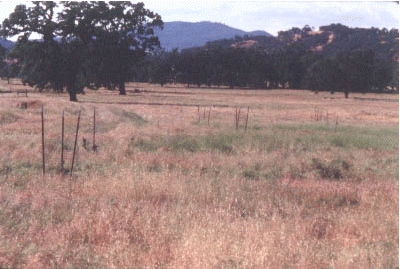
Pope Valley, CA 1989.
|
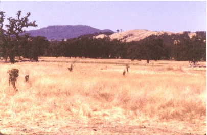
Pope Valley, CA 1995. Note hillside clearing, decline of large valley
oaks on valley floor at left, and growth of oak seedlings protected
from grazing.
|
Aerial photo points
An aerial photo point is simply a variation of the use of aerial photography
described under
Photogrammetry and remote sensing
techniques. Permanent plots are established based on easily recognizable
features such as roads, buildings, utility corridors, or landforms, so
that the same area can be compared in successive photographs. Photographs
should be printed at the same scale to facilitate direct comparisons. Transparent
overlays can then be used to pinpoint the location of specific trees in
different photographs.